Khaliya Top Trek Guide: Complete Route, Difficulty, Best Time & Travel Tips
Khaliya Top is the most popular day trek near Munsiyari, Uttarakhand, reaching an altitude of roughly 3,500 metres (11,480 feet) with panoramic views of the Panchachuli Peaks, Nanda Devi, Hardeol, Rajrambha, and Nandakot. The trek covers 5–6 km one way, takes 2 to 3 hours to ascend, and is rated easy to moderate, making it one of the most accessible high-altitude treks in the Kumaon Himalayas.
I grew up in Madkot, a village close to Munsiyari, and Khaliya Top is the trek I keep coming back to. It looks different every time: rhododendrons in spring, bare alpine grass in autumn, snow from December onward. If you’re building a Munsiyari itinerary and can only add one trek to it, this is the one.
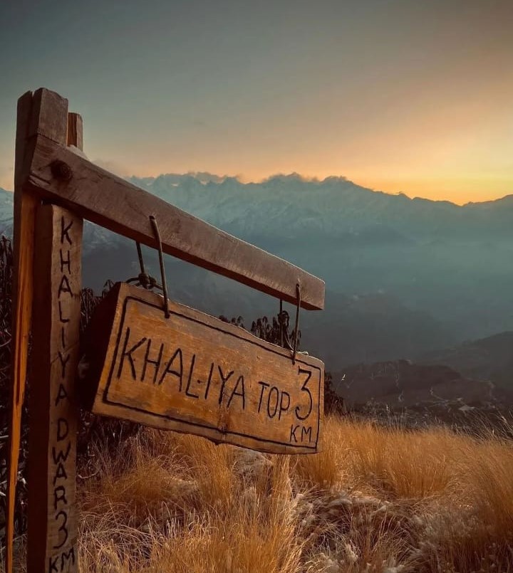
SUNSET VIEW OF KHALIYA TOP
Quick Facts About Khaliya Top Trek
| Information | Details |
|---|---|
| Location | Munsiyari, Pithoragarh District, Uttarakhand |
| Altitude | Approximately 3,500 m (11,480 ft) |
| Trek distance | 5–6 km one way (varies by starting point) |
| Trek duration | 2–3 hours up, 1.5–2.5 hours down |
| Difficulty | Easy to moderate |
| Best time | March–June and September–November (December–February for snow) |
| Winter snow | December–February |
| Suitable for | Beginners, families, photographers, nature lovers |
Where Is Khaliya Top?
Khaliya Top sits just above Munsiyari town in Pithoragarh district, one of the eastern-most districts of Uttarakhand. The trail starts near the Khaliya Top Eco Park and climbs through Himalayan forest before opening into alpine meadows (locally called bugyals). Because the trailhead is a short drive from Munsiyari’s main market, Khaliya Top is one of the few ways to reach a genuine high-altitude viewpoint without committing to a multi-day expedition, unlike the longer Milam or Ralam Glacier treks that also start from Munsiyari.
Why Is Khaliya Top Famous?
Khaliya Top is known for three things: uninterrupted views of the Panchachuli range, open alpine meadows, and its accessibility as a single-day summit-style trek. Most Himalayan viewpoints at this altitude require two or three days of trekking; Khaliya Top delivers comparable scenery in a single morning. Uttarakhand Tourism itself features Khaliya Top as one of the state’s standout viewpoints, which reflects how the trail has grown from a local secret into one of Kumaon’s better-known short treks over the past decade.
Khaliya Top Trek Difficulty
The trek is generally rated easy to moderate. The trail gains elevation steadily through switchbacks but involves no technical climbing, scrambling, or exposed sections. Most healthy adults with average fitness complete it comfortably in a single day.
| Factor | Rating |
|---|---|
| Physical effort | Moderate |
| Technical difficulty | Easy |
| Trail condition | Well-defined |
| Suitable for beginners | Yes |
| Suitable for children | Older children, with supervision |
If this is your first Himalayan trek, Khaliya Top is a reasonable place to start before attempting longer routes like Milam Glacier.
Trek Route
The standard route follows this path:
Munsiyari → Khaliya Eco Park → Oak Forest → Rhododendron Forest → Alpine Meadows → Khaliya Top
The lower section climbs gradually through oak and pine forest. As the trail gains altitude, dense woodland thins into open grassland, and the Himalayan skyline becomes visible for the first time. In spring, the rhododendron stretch adds a band of red and pink through the forest, which is worth timing your trek around if photography is a priority.
What Can You See From Khaliya Top?
On a clear day, the summit view includes:
- Panchachuli Peaks
- Nanda Devi
- Nanda Kot
- Hardeol
- Rajrambha
These five to six named peaks are the entire reason most people make the climb. Visibility depends heavily on season and time of day; see the table below for when the odds are best.
Best Time to Visit Khaliya Top
| Season | Conditions | Recommendation |
|---|---|---|
| March–June | Pleasant weather, blooming rhododendrons | Excellent |
| July–August | Heavy rain, slippery trails | Not recommended |
| September–November | Clear skies, best mountain visibility | Excellent |
| December–February | Snow-covered landscape | Excellent for snow, check trail conditions first |
October typically gives the clearest views of the Panchachuli range, since post-monsoon air has the least haze.
How Long Does the Trek Take?
Most trekkers take 2–3 hours going up and 1.5–2.5 hours coming down. Including photography stops and rest breaks, plan for 5–7 hours total, door to door from Munsiyari. Starting early gets you cooler temperatures on the climb and clearer visibility at the top, since cloud cover tends to build through the afternoon.
What Should You Carry?
- Comfortable trekking shoes
- Warm jacket
- Water bottle
- Snacks
- Rain jacket (monsoon season)
- Sunglasses and sunscreen
- Power bank
- Camera
- Basic first-aid kit
Temperatures drop fast once you’re above the tree line, even in May or June, so pack the warm layer regardless of the season down in town.
Is Khaliya Top Safe?
Yes, generally, for a beginner-level trek. A few practical precautions:
- Avoid trekking during heavy rainfall.
- Stay on the marked trail.
- Carry enough drinking water; there are limited refill points.
- Check the weather forecast before you start. India Meteorological Department’s Uttarakhand bulletin is a reasonable source for mountain-weather updates.
- Start early enough to avoid descending after dark.
After recent snowfall, sections of the trail can turn slippery. Local guidance is worth arranging in that case rather than attempting it solo.
Local Tips From My Experience
Growing up near Munsiyari taught me that the small decisions matter more than the big ones on this trek:
- Start as early as you reasonably can. The clearest views are almost always in the first few hours of daylight.
- Carry an extra warm layer even in May or June; the meadows are colder than the forest below.
- Spend real time in the alpine meadows instead of rushing straight to the summit marker and back.
- If you’re there in spring, the rhododendron forest is worth slowing down for; it’s one of the more photogenic stretches in the whole Munsiyari area.
- Himalayan weather shifts quickly, so build buffer time into your schedule rather than planning it to the hour.
Nearby Places to Visit After Khaliya Top
If you have two or three days in Munsiyari, pair this trek with:
- Panchachuli Viewpoint
- Birthi Falls
- Darkot Village
- Nanda Devi Temple
- Tribal Heritage Museum
Together, these cover most of what makes Munsiyari worth the long drive in.
Frequently Asked Questions
Is Khaliya Top Trek suitable for beginners? Yes. It’s rated easy to moderate and suitable for beginners with basic fitness, no prior high-altitude trekking experience required.
How difficult is Khaliya Top Trek? Physically moderate, technically easy. There’s no climbing or exposed scrambling, which makes it one of Uttarakhand’s more approachable Himalayan treks.
How much time does the trek take? Most people finish the round trip in 5–7 hours, depending on pace, fitness, and weather.
Does Khaliya Top receive snowfall? Yes, typically from December to February, though the exact window shifts year to year.
What is the best time to visit Khaliya Top? March to June for pleasant weather and blooming rhododendrons, or September to November for the clearest mountain views.
Can children do the trek? Older children comfortable walking uphill for a few hours can usually manage it with adult supervision. It’s not recommended for very young children given the altitude and distance.
Conclusion
Khaliya Top packs a genuine high-altitude Himalayan view into a single accessible day trek, which is rare in this part of Uttarakhand. Whether you’re in Munsiyari for trekking, photography, or just to see the Panchachuli range up close, this is the trail to prioritize.
For background on the town itself, altitude, and district, see the Wikipedia entry on Munsiari.